Last week my sister and I took a day trip to the tip of the Upper Galilee, to the nature reserve of Nachal Iyun. One of the streams to feed into the famed Jordan River, Nachal Iyun emanates from springs in the Marjaayoun Valley in Lebanon, just north of the town of Metula. The Lebanese town and valley Marjaayoun means “meadow of springs” in Arabic, making Nachal Iyun meaning “stream of springs” and so it is. The Israeli part of the stream, and its series of waterfalls, curls around Metula bordered by the Israel-Lebanon border (the “Blue Line”) before petering out near Kiryat Shmona.

Anemone with bee
On our drive up we passed by a sizable collection of police, military and firefighting crews who had blocked off the opposing side of Road 90. Later I learned that there were terrorists spotted in Lebanon trying to place mines along the border. Just another day in Israel… But that didn’t stop up from enjoying some homemade herb biscuits with butter and cheese en route. We found the park, parked and began our hike of the nature reserve.

The view to the Naftali Mountains
But what’s a nature hike without a sprinkling of regional history? The area of Iyun, and even the stream itself, are mentioned several times in the Bible and subsequent books by the Sages. First, the retelling of scuffles between the divided Jewish kingdoms of Israel and Judah. King Asa of Judah, great-grandson of King Solomon, gave Iyun (as well as Dan and other Naftali cities) to King Ben Hadad of Aram Damascus as a bribe to turn the Aramaeans against the Kingdom of Israel under King Baasha. Later, it’s mentioned as the border of Galilee in regards to religious commandments applicable only to the Holy Land. In more modern times, the bridge over the stream connecting Israel and Lebanon was blown up by the Palmach, one of eleven bridges targeted in the “Night of the Bridges” operation. These days there remains a threat from the Hezbollah terrorists who have control over southern Lebanon; in 2005 they diverted the stream within Lebanon and today water is supplemented from the neighbouring Snir Stream.

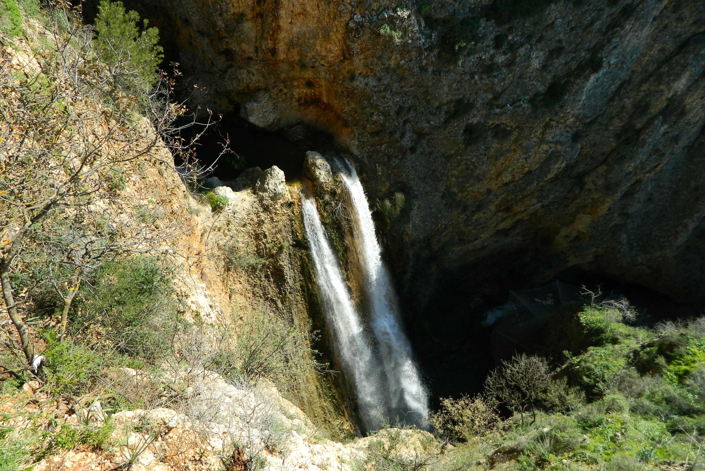
Looking up through the chimney of HaTanur Waterfall
After a short walk we reached the first of the four waterfalls: HaTanur Waterfall. A towering 30 metre (~100 foot) waterfall crashing into the soft limestone, the name HaTanur has three possible origins: a long Arab skirt, an chimney oven and a fast flowing current. We stood at the base and enjoyed the mist and the cold air, although it tended to make photography difficult.

It’s me!
Taking the winding trail-steps up the side of the gorge far above the falls, we passed by Metula’s cemetery with some gravestones from the late 1800’s. Reaching HaTanur Waterfall Lookout, we walked onto a platform jutting out over the edge of the slope to see the falls below.
HaTanur Waterfall from above
We continued on along the rim of the gorge until we reached very unusual steps leading down to the second waterfall: Cascade Falls. This two-stepped waterfall is on a much smaller scale, 9.5 and 5 metres (31 and 16.5 feet), with a bit of an unimpressive vantage point. In the winter months some 0.3-1.5 cubic millimetres of water flow through the stream each second but we visited not long after a pretty big storm so I’d imagine we were seeing a bit more. Just a few hundred metres further on the trail of the two-kilometre gorge we reached the beautiful Mill Falls, the third waterfall.

Mill Falls
An impressive 21 metres (69 feet) tall, Mill Falls is named after the remains of an old mill of which a tall wall and an uncovered arched structure can be still seen, built against the rock wall. I haven’t found any information about this mill which is a bit strange. Walking up the trail-steps to the Mill Lookout we watched water from the adjacent Ein Sucra spring trickle down a trough parallel to the trail. With the noise of the crashing water slowly fading behind us, we climbed in elevation once again heading for the final waterfall. At one point fairly close to the border we spotted a Lebanese shepherd and his goats grazing on the far ridge. We discussed whether or not he might be a Hezbollah spy – a pretty realistic assumption. Last time I encountered a Lebanese herd was when I was up in the Gladiola Outpost at the top of nearby Mount Dov and a wayward Lebanese herd found its way into the outpost and panicked when they tried to get back out. Two goats fell down a small cliff and some got cut up on the razor wire – it was quite a mess. You can see a picture of it HERE.

Lebanese shepherd with his goats
Shortly thereafter we entered a different park of the reserve, the Founders Grove with its tall trees and bubbling brook atmosphere. We spotted European robins flitting in the bushes and turtles basking in the sunlight. We then came to the end of the trail and the fourth waterfall: Iyun Waterfall.
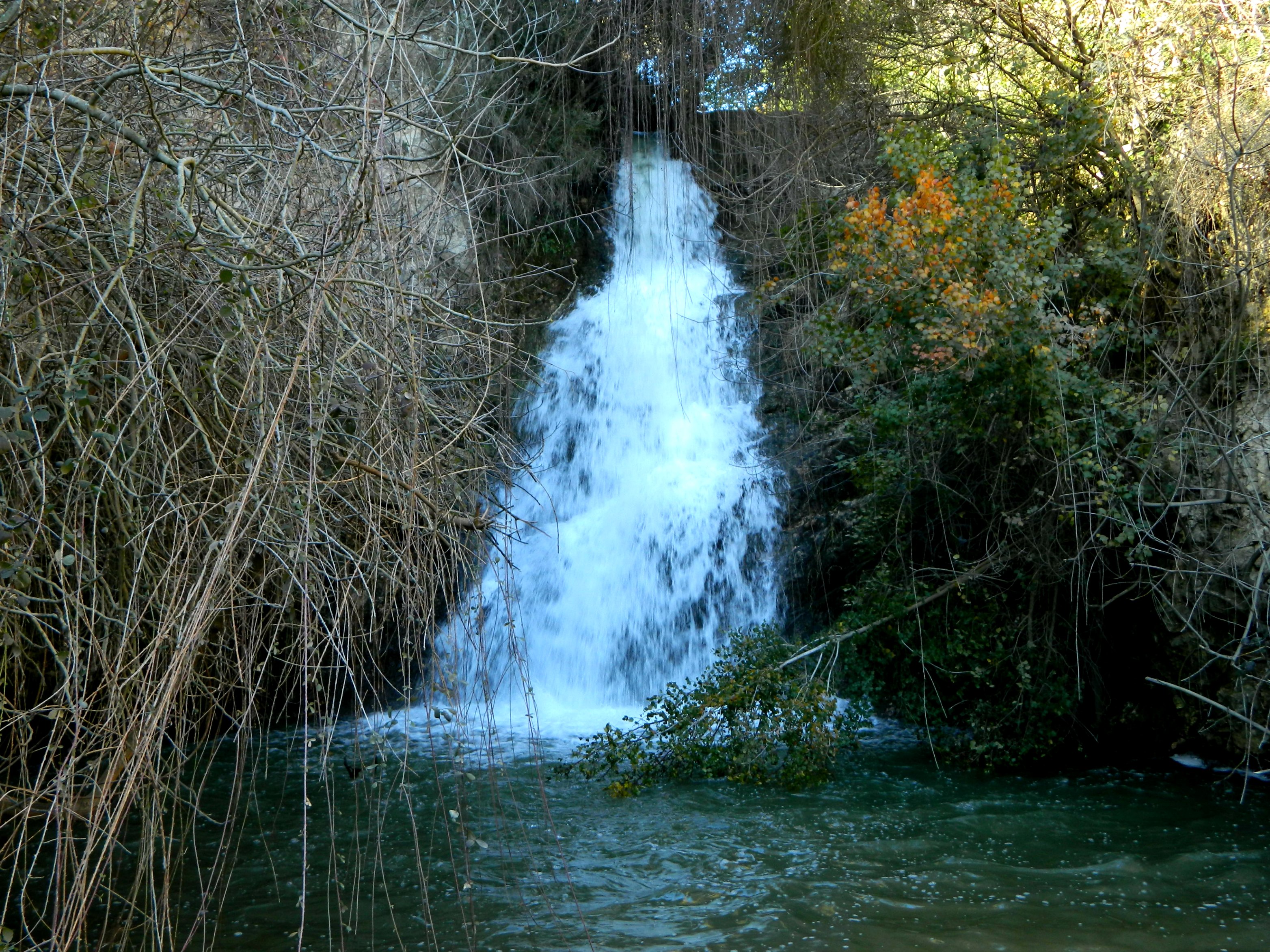
Iyun Waterfall
Although it doesn’t quite look it in the above photo, this waterfall is 9.2 metres (30 feet) tall and the water up top was used by the British in the 1940’s. With that we turned around to hike back to the car (there is no long circular path). Being as though we were now facing the opposite way this time, we saw things at a different angle. It was only on the way back that I noticed the Dove Cave between the Cascade Falls and HaTanur Waterfall. In addition, we spotted deep wild boar tracks in the mud. But best of all, the magnificent view – this is looking at HaTanur Waterfall Lookout with the Gafni Lookout below:

Looking out at the lookout
Finished with the hike we got into the car and stopped off at Rosh Pina for some super-thin authentic Sicilian pizza before driving home.