Israel's Good Name

Bar’am

In Galilee, Israel on August 9, 2015 at 5:08 AM

The other week I went on a two-part trip, of two consecutive days, to Bar’am and the surrounding area, not far east of Ma’alot in the Galilee. The first trip was with my parents and my brother and we were only going with the purpose of visiting some graves (keverim) of sages and prophets of yore. We drove on the Old Northern Road and then turned onto Road 8967, passing the national park of Bar’am and pulling over at the signs denoting keverim.

Kever of Nachman Chatufa

Kever of Nachman Chatufa

The first kever was that of Nachman Chatufa, a boy wonder of sorts who was born some 1,500 years ago speaking words of Torah and prophesies upon birth. Shocked, his father muted him and it wasn’t until Nachman’s 12th birthday that he opened his mouth releasing a torrent of prophesies – then fell over and died. The second kever, about a hundred metres south, is that of Mar Zutra, an Amora who lived in Babylon some 1,400 years ago or so. When we were leaving Mar Zutra’s kever we noticed that there was an old archaeological dig between the kever and the old Christian cemetery of Bar’am (or as they’d say, Biram). Upon closer examination we found “abandoned” and unmarked wall sections still partially buried, a carved stone that looks like it might be an ornate lintel or something along those lines and, of course, loads of potsherds.

Unnamed archaeological dig

Unnamed archaeological dig

I’m very curious to learn more about this dig but haven’t found anything online and I’m waiting to hear back from the Antiquities Authority. A hundred and forty metres north of Nachman Chatufa’s kever is the grave of the prophet Ovadya (Obadiah), of Biblical fame. It was he who hid one hundred prophets from the wrath of the wicked king and queen of Israel at the time, Ahab and Jezebel, sustaining them in their cave hideouts until he depleted his great reserves. It was also he who was the “pawn” in arranging the meeting between King Ahab and Eliyahu (Elijah) the Prophet before the famous sacrificial showdown on Mount Carmel. I found his story and his kever location to be most interesting. We drove back home after that, and it was on the next day around noontime that I set out again to visit more sites in the area – this time alone.

Overgrown ruins of Bar'am

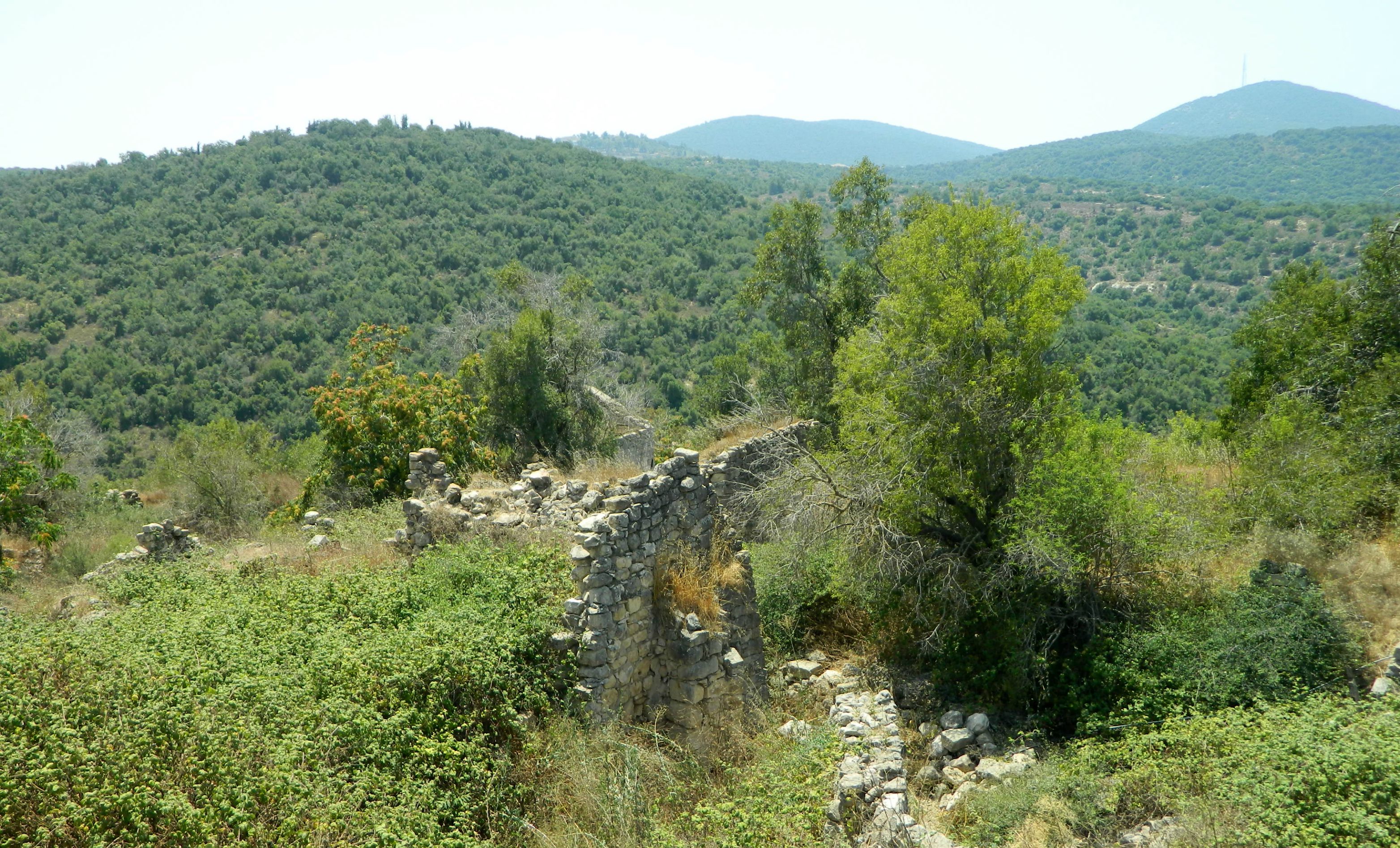
Overgrown ruins of Bar’am

I began with the Bar’am National Park, which we had visited as a family years ago before I started my blog, hosting one of the most beautiful ancient synagogues in the country. One of the smallest national parks I’ve ever been to, there are many unmarked ruins of houses around the parking lot and then pieces from the great synagogue on display.

Synagogue pieces on display

Synagogue pieces on display

The showcase of the park is, of course, the aforementioned synagogue from the Talmudic era. With excavations on the synagogue starting in 1905, the magnificent columned structure had been slowly uncovered and its architecture and layout have proven most interesting to researchers.

Bar'am's main synagogue

Bar’am’s main synagogue

There is another, smaller synagogue just a few hundred metres from the main synagogue that was discovered even earlier by a British survey team. The lintel, with an inscription by Yosef HaLevi – the stonemason who carved it, now resides at the Louvre Museum in Paris with a replica being held at the Bar-Dor Museum in Kibbutz Bar’am. Unfortunately, this smaller synagogue is unmarked so I cannot be sure if I saw it or not. Just after the main synagogue is an old church of the Maronite sect of Christianity, with the remains of their village Biram which was built on the remains of the ancient Jewish settlement.

Entrance to the Maronite church

Entrance to the Maronite church

After leaving the national park, I kept driving a bit further on the Old Northern Road until I reached a small access road to the peak of Mount Shifra (elevation: 730 metres) where KKL-JNF built an observation tower. When I reached the top I was disappointed to see the area blocked off due to construction – I can only hope that they are improving the Bar’am Tower. Abandoning the area I drove back west until I got to the Pa’ar Cave, parking at the roadside gravel lot. Getting out of my car I noticed something strange at the edge of the parking lot… What I found were two or three wild boar corpses being consumed by maggots, presumably the results of hunting/poisoning from the way they were laid out (just guesswork).
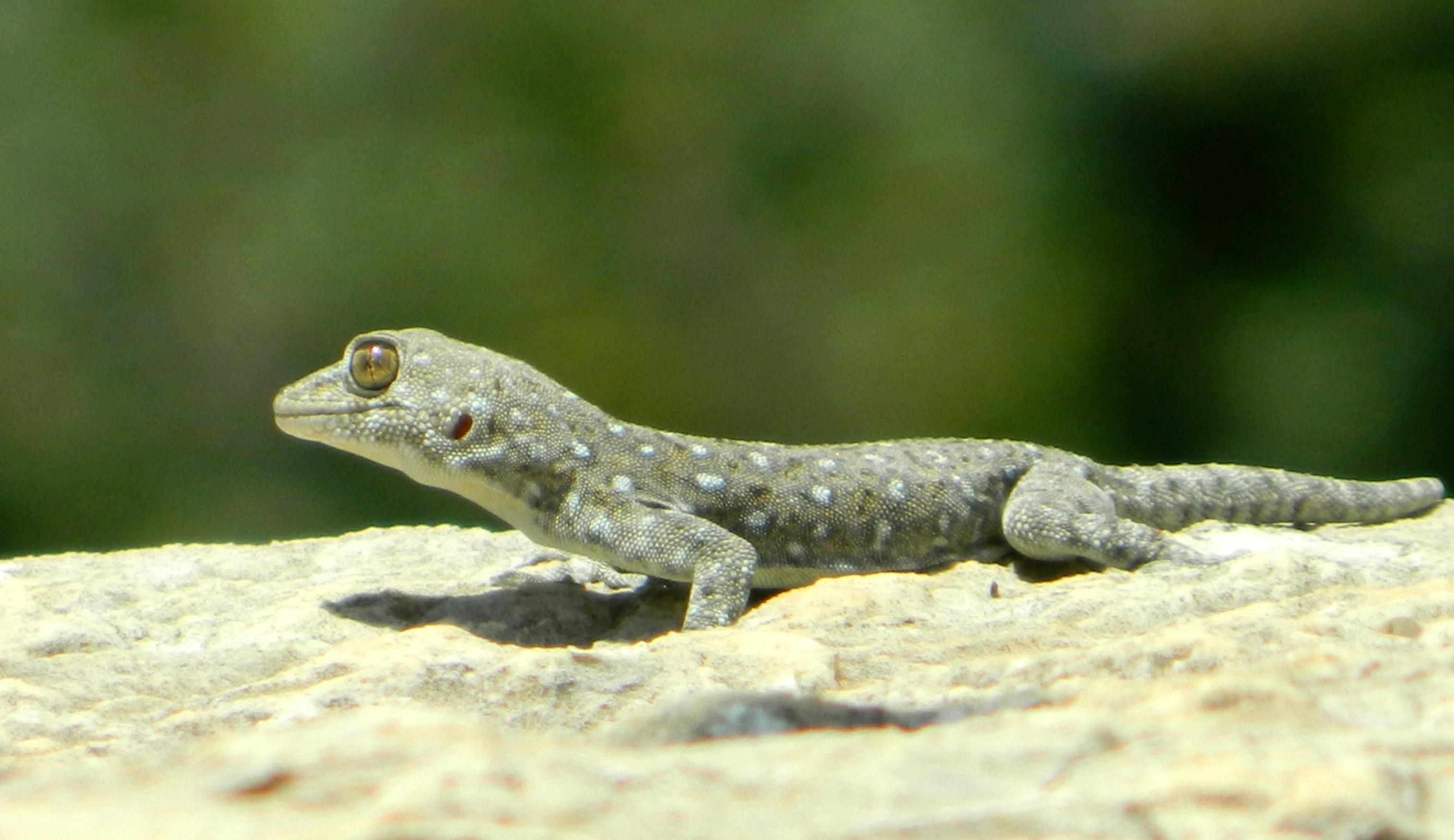
Fan-fingered gecko

Fan-fingered gecko

What I found next, in the grass nearby, brought me great joy – a clean skull! Unfortunately, the impressive tusks are on the lower jaw which becomes separated from the skull after decomposing, but there are still smaller tusks on the upper jaw – this image is the best I can find to illustrate the layout of boar jaws. Grabbing some newspaper I claimed my prize and the skull is now in my backyard getting sun-bleached everyday until it is fit for displaying. With the skull safely locked in the car I headed on over to the cave, just about a hundred metres from the road via a dirt trail. When I reached the cave I could hear the sounds of humanity emanating from the chasm, as a group of merry-makers had also chosen this hour to visit the cave.

Visitors in the Pa'ar Cave

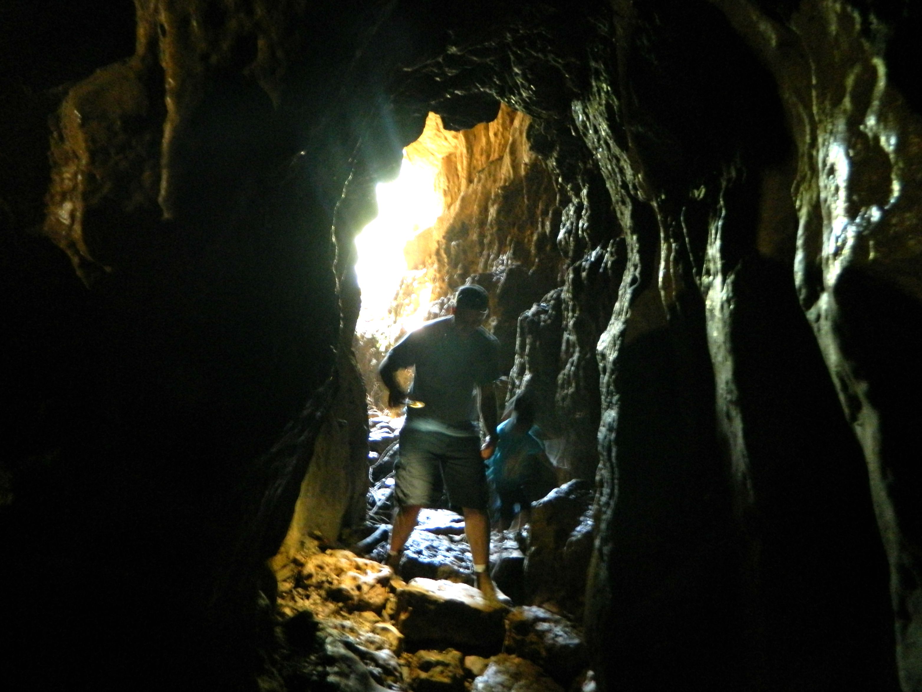
Visitors in the Pa’ar Cave

And so I shared my brief spelunking experience with these fine individuals, enjoying the light of their flashlights as I had forgotten to pack one. I intend to return one day and properly explore this karstic sinkhole as I’ve heard the cave goes very deep/far and I’d like to verify that myself.

Pa'ar Cave from the outside

Pa’ar Cave from the outside

Continuing on to my trip’s final destination, I drove up the nearby Mount Adir (elevation: 1,008 metres) to hike the brief summit trail. Just as I was reaching the peak I saw what I believe was an eagle of sorts taking flight from a fence post; I’d love to have gotten a picture. At the new top I parked and continued on foot headed along the trail with the green marker to the Mount Adir lookout. Dedicated in 2012 to the soldiers who died in battle during the Second Lebanon War (2006), the wooden balcony provides a great view overlooking Lebanon, including many of the battle sites where Israeli lives were tragically lost. One thing that piqued my interest was looking down on the Tegart fort on Mount Metat (interestingly enough, the gematria of Metat in Hebrew is 840 and the mountain’s elevation is 840 metres above sea level).

Mount Adir lookout over the border

Mount Adir lookout over the border

Having read that there was an ancient fortress discovered and partially uncovered from the 1960’s, I set out on the green trail to find it. Continuing onward and onward along the flat peak, I circumvented a military installation and discovered that I was actually heading down the mountain back towards the Pa’ar Cave. Unable to ascertain whether or not the green trail was circular I turned back and it was when I was passing a rusted piece of army bunker, along the northen edge of the summit, that I noticed a wall partially uncovered. I believe that this must be the ancient fortress, which is thousands of years old and is believed to have been built by the Phoenicians. With that I headed back to the car, pausing briefly to examine the remains of a kestrel in the grass, and drove back down the mountain to home.

Tiberias: Holy Tombs

In Galilee, Israel on July 27, 2015 at 8:58 AM

Continuing on with the trip my father and I took to the city of Tiberias in August of last year, we left the Old City and drove up the hillside in search for a number of keverim – holy tombs of Jewish sages. Being that Tiberias is one of Judaism’s four holy cities (the others being Jerusalem, Hevron and Tzfat), the Jewish presence was strong in the lakeside town for thousands of years. Many great rabbis called Tiberias and the surrounding villages their home, and thus many were buried throughout the city over the generations.

The Maimonides Heritage Center

The Maimonides Heritage Center

Our first stop was to the kever of the Rambam (Maimonides), a great scholar, philosopher, author and physician who lived in Spain and North Africa in the 1100’s. Interestingly enough, the Rambam was appointed physician to Saladin (of Crusader fame) and it is believed that through his position in the Ayyubid sultan’s court he was able to ransom Jewish captives from the hands of the Crusaders. The Rambam passed away in Egypt and his body was taken to Tiberias for burial, where today it is a city landmark.

Jews of all sorts praying at the kever of the Rambam

Jews of all sorts praying at the kever of the Rambam

We spent a few minutes at the kever, pausing at neighbouring keverim of earlier sages such as the Tannaim R’ Elazar ben Arach and R’ Yehoshua ben Chananya (who was the Rosh HaYeshiva in Peki’in). Among the many other great sages buried there include Rav Ami and Rav Asi – both Amoraim – as well as R’ Eliezer ben Hyrcanus of Mishnaic fame. One really strange burial site was simply named “collection of bones”- I wonder whose bones and from what era…

Conjoined keverim of early sages

Conjoined keverim of early sages

Overlooking the kever of the Rambam is the Maimonides Heritage Center which has a small museum on the Rambam as well as hosting various activities and events for groups. Chronicling the life, the works and the legacy of the Rambam, there is much to be learned for all visitors of the centre. Rabbi Michael Schachter was gracious enough to give us the full guided tour – which we found rather informative.

Rabbi Michael Schachter

Rabbi Michael Schachter

Taking leave of the Maimonides Heritage Center we drove up the hill to the kever of R’ Akiva, one of the greatest Jewish sages of all time, who was martyred by the Romans. Of humble beginnings, R’ Akiva married the daughter of the wealthy Kalba Savua of Jerusalem and then, after being ostracised by his father-in-law, left to study – through great self-sacrifice for both him and his new bride, Rachel. Beginning in the yeshiva of the aforementioned R’ Eliezer ben Hyrcanus, R’ Akiva rose to lofty spiritual heights and amassed 24,000 students in the course of twelve years. After the failed revolt of Bar Kochba, R’ Akiva was sentenced to death by the Romans and was buried on the hillside above ancient Tiberias.

Inside the kever of Rabbi Akiva

Inside the kever of Rabbi Akiva

Beside the kever of R’ Akiva is the kever of the Ramchal (or R’ Moshe Chaim Luzzatto), a rabbi, kabbalist and philosopher from the 1700’s. Born in Italy and having spent time in Amsterdam, the Ramchal’s teachings were often rejected by the local rabbinate and his books were even burned. Frustrated, the Ramchal moved to the Holy Land and settled in port city of Akko. Tragically, he and his family perished in a plague but his teachings live on as a staple for self-improvement and piety. From the stone plaza just outside these two keverim, the most magnificent view of Tiberias and the Kinneret (Sea of Galilee) is to behold.

Looking down at Tiberias and the Kinneret

Looking down at Tiberias and the Kinneret

Stopping off briefly at a supermarket for lunch supplies, we continued south until we reached the kever of Rachel, the wife of R’ Akiva – a saint in her own right. Overlooking a waterpark and the ancient Jewish cemetery, we stopped to both pray and take pictures.

Remains of the ancient Jewish cemetery

Remains of the ancient Jewish cemetery

Back on the road, we drove along the water passing two sites I intend to visit on a later trip: Berko Archaeological Park and Hamat Tiberias (hot springs held in great value since antiquity). Our final destination was the kever of R’ Meir Ba’al HaNes (who name translates to R’ Meir the Miracle Maker), another great sage from the period of the Tannaim. A student of R’ Akiva – one of the only five to survive the terrible plague, R’ Meir requested to be buried in the Holy Land in a place where the water would lap at his grave. And so, when he passed away, his body was brought to rest at the foot of the low mountains along the banks of the Kinneret.

The R' Meir Ba'al HaNes complex

The R’ Meir Ba’al HaNes complex

We had lunch at the tables outside the complex and then entered to visit and pray. Afterwards, we called it a day and headed back home, missing yet a few of the important keverim that we didn’t know about at the time. Another trip is now most certainly in order…

Tiberias

In Galilee, Israel on July 19, 2015 at 6:07 AM

Nearly a full year ago, shortly before going on the wine tour (starting with the Tishbi Winery in Zichron Ya’akov), I went on a day trip to Tiberias (also known as Tverya) with my father. Although being a very important city historically, and just a short drive away, Tiberias hadn’t been at the top of my lists and has therefore been neglected for far too long. However, I shall now right that wrong and regale the tale of our journey.

Tiberias in the 1920's

Tiberias in the 1920’s

We started out early in the morning, grabbing some borekas and a sfinj (Moroccan doughnut) from the local Peace Bakery. We stopped once along the way, just minutes from Meron, at some ancient graves of Jewish sages, which dot the Galilee with their mystical blue domes. Shortly thereafter, we were driving along the Kinneret (Sea of Galilee) on Israel’s longest highway – Road 90 – and we entered Tiberias from the north. Searching for the visitor information centre in the Old City, we parked and went to pay for parking at the designated machine. When we returned, a parking violation ticket was sitting on the windshield and so we went on a merry chase demanding justice, for our ticket and the parking slip we purchased were time-stamped at the same time, to the minute. We ended up in a government office where we filled out a form protesting our fine and with that hiccup taken care of, started our tour of Tiberias.

The visitor centre building with ruins of an ancient synagogue

The visitor centre building with ruins of an ancient synagogue

Picking up information at the visitor centre, which is actually housed inside old ruins of an ancient synagogue – one of the city’s thirteen mentioned in the Talmud, we started our walk around the Old City. Right beside the parking lot is the Court of the Jews, the first modern Jewish community founded in 1740 during the era of the Bedouin ruler Daher al-Omar. Surrounding this cobblestone square are a handful of synagogues and yeshivas of various antiquity. The oldest, the Etz HaChayim Synagogue, was built in 1742 by Rabbi Chaim Abulafia of Smyrna and was a major centre for religion in the region for many years. Due to Tiberias’ location on a faultline, the city was wracked numerous times by violent earthquakes, and in 1934 a great flood ravaged Tiberias, permanently reshaping its coastline.

The Old Synagogue from 1836

The Old Synagogue from 1836

Beyond the synagogue is the gate of the Crusader fortress, a wooden bridge crossing over an empty moat, with the old Jewish quarter now covering the remains of the Crusader fortress. During the Crusader times, the city changed hands a few times before the Mamluks finally drove the Franks permanently out five years after stopping the Mongol invasion some thirty kilometres southwest of the city. Reaching the waterfront, we walked along the boardwalk watching the boats sail against the hazy backdrop of the low mountains on the Golan side of the Kinneret.

Southern end of the Old City with Mount Berniki in the background

Southern end of the Old City with Mount Berniki in the background

With the water level of the Kinneret being a national concern, Israel’s water company Mekorot installed a water level surveyor on the boardwalk to publicly display the current level. Last post (Yarkon National Park) mentioned how most of the country gets its water, and it’s at the Kinneret where the artifical journey begins. Now it is the summer, Israel’s dry season, so the water level reports are mostly the gradual evaporation of the Kinneret but during the winter and spring, the water levels rise dramatically after heavy storms and there is actually a Twitter account dedicated to reporting the water levels throughout the year: @kinbot.

Mekorot water level surveyor

Mekorot water level surveyor

With the current levels being “below red lines”, it is hard to imagine the flood of 1934 which destroyed a good portion of the city, and there are even markers today which show just how far the water reached on the walls of the lakeside buildings. We peeked into the Tiberias Rowing Club and then passed the Greek Orthodox Monastery whose leaning corner tower has become quite an icon in the Old City. Visiting the rocky, and surprisingly littered, beach we then walked back towards the heart of the city alongside the old Crusader wall (rebuilt by Daher al-Omar), enclosing the city from the south, under the shade of beautiful orange-blossomed royal poincianas.

Tiberias' Leaning Tower

Tiberias’ Leaning Tower

In the shadows of numerous hotels, we found our way to the abandoned al-Omari mosque, hidden behind a strip of closed storefronts. A local informed us that the city plans to renovate the area and make it more of an attraction; I wonder if the mosque will get similar treatment.

al-Omari mosque

al-Omari mosque

We continued heading north, walking among the dark grey stone buildings until we reached the Saraya. A large Ottoman government building, sarayas can be found in several old Israeli cities including Tzfat (Safed) and Akko, where the regional commands was located. Tiberias’ Saraya is two floors; the upper being the governor’s residence and office while the lower floor contained jail cells and stables for the Ottoman postal service. Slightly further north is the Fortress built by Daher al-Omar’s son with its impressive tall basalt walls and round corner towers.

Tiberias Fortress

Tiberias Fortress

When we were done looking around the fortress area, and we were sure we saw everything of interest in the Old City, we returned to the car for the second leg of our Tiberias trip – coming next!